El Niño Is Here
Air Date: Week of June 19, 2026
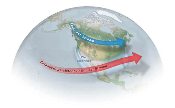
The El Niño phenomenon pulls the Pacific jet stream eastward, carrying wetter conditions to the western U.S. and Mexico and drier conditions to the north. (Photo: NASA, Joshua Stevens, modified by Michala Garrison)
The 2026 El Niño is now officially underway, according to the National Oceanic and Atmospheric Administration or NOAA. Combined with the ongoing rising temperatures from the climate crisis, this possible “super” El Niño could spell major disruption of weather patterns and ocean circulation worldwide. Kevin Trenberth, scientist at the University of Auckland in New Zealand as well as a Distinguished Scholar at the National Center for Atmospheric Research in Boulder, Colorado, joins Host Jenni Doering to explain.
Transcript
BELTRAN: From PRX and the Jennifer and Ted Stanley Studios at the University of Massachusetts Boston, this is Living on Earth, I’m Paloma Beltran.
DOERING: And I’m Jenni Doering.
El Niño is a periodic phenomenon every few years in which a tropical region of the Pacific experiences unusually warm ocean surface temperatures, affecting weather patterns across the world. And a 2026 El Niño is now officially underway, according to the National Oceanic and Atmospheric Administration or NOAA, which also said this one has a greater than 50% chance of turning into a “super” El Niño. Combined with the ongoing rising temperatures from the climate crisis, a “super” El Niño could spell major disruption of weather patterns and ocean circulation worldwide. Joining us now from New Zealand to explain the impact is Kevin Trenberth, scientist at the University of Auckland as well as a Distinguished Scholar at the National Center for Atmospheric Research in Boulder, Colorado. Kevin, welcome back to Living on Earth!
TRENBERTH: Thank you very much.
DOERING: For those of us who don't remember from high school earth science, what is an El Niño?
TRENBERTH: An El Niño refers to an exceptional warming of the central and eastern tropical Pacific Ocean. El Niño can be thought of as a way of regulating the temperatures. The reason is the Pacific Ocean is huge in the tropics, and it extends more than a quarter of the way around the globe. The sun is beating down. It heats up the surface of the ocean, but there are trade winds, easterly trade winds in the tropics, and along the equator. It picks up all of that warm water and dumps it in the Western Pacific, and it forms a huge deep pool of warm water, and it gets to a point where so much heat is stored up there, the Pacific sort of says, "I can't stand it anymore. I'm going to have an El Niño." And all of that warm water starts to surge across to the Eastern Pacific, which it has done this year already, and it influences the atmosphere as it goes. And at some point during the year, usually after about September, mainly, it changes the atmospheric circulation. It changes where all of the rains occur in the tropical Pacific. It's already beginning to do that, but the annual cycle is working against it at the moment, and it tends to pick up in the Northern Hemisphere winter, and the strongest effects occur late in the year, typically peaking around December, and that's in the Pacific. And globally there is a mini global warming, which tends to peak around February of the following year, so that would be February of 2027.

Kevin Trenberth, a New Zealand-American climate scientist studying climate variability and ocean processes (Photo: New Zealand Government, Office of the Governor-General on Wikimedia Commons, public domain)
DOERING: For an El Niño, there's all this heat building up in the Pacific Ocean, and it needs to be released. What makes an El Niño a super El Niño?
TRENBERTH: So we monitor a particular index, a tropical region in the Pacific, and if it gets to be above two degrees Celsius over this extensive area above the overall average, then we call it a very strong El Niño. And so we have these different grades of, you know, strong, moderate, weak El Niño, and very strong. There are no very strong La Niñas, which is the other phase where it's very cold, but there are these big El Niño events, and they've been about three of them.
DOERING: Why is this important? Understanding how this El Niño is working this year, and what were the impacts of previous strong El Niños?
TRENBERTH: So El Niños have strong what we call tally connections, links, huge wave patterns that extend into both hemispheres. They change the distribution of tropical storms substantially where they occur, hurricanes and the risk of hurricanes. And in an El Niño event, there tends to be a greater risk that there will be strong storms coming into Southern California and throughout the southern parts of the United States, but probably less action in the northern parts of the US and Southern Canada, and so it has a big influence on rainfall patterns. It also can have a big influence, then, on the risk of things like wildfire, and in the western parts of the United States, it's been very warm, very dry, and the risk of wildfire is already quite high. So it's very important, actually, to get the rains in parts of this region, but there are some regions, maybe Northern Colorado, for instance, that might be at considerable risk for things like wildfire.
DOERING: So that's some of the impacts in the US. What about in the global south? I understand that in previous years we have seen pretty significant impacts from El Niño.

Much of the American West is vulnerable to increased wildfires during a strong El Niño year. (Photo: Kyle Miller, Wyoming Headshots via USFS, Wikimedia Commons, public domain)
TRENBERTH: So depends a little bit on how quickly this thing develops, but already this is the time of year when the Southeast Asian monsoon tends to develop, and having more action out in the Pacific, more convection, more rainfall, and so on tends to detract from the rainfall in the monsoons. And so it means that there's a real risk that the monsoons may be much weaker than normal, less rainfall all throughout Southeast Asia, and of course this has very profound influences, because eight months of the year it's dry. And they're very dependent upon the monsoon rains for all of their agriculture and growth of crops and so on, and so this is a major concern for that region.
DOERING: And then, how about Africa? What do different parts of Africa see in an El Niño year?
TRENBERTH: So it can get a bit more complicated then and it depends a bit more on just what happens in the tropical Indian Ocean, for instance. So normally warm water from the Pacific flows into the tropical Indian Ocean, and this has an influence in Eastern Africa, in particular, and it can affect drought and flooding, and also outbreaks of various kinds of diseases and insects that can cause problems, but each El Niño tends to be somewhat individual in characters to just how this plays out.
DOERING: I mean, this is incredibly complex. Would it be accurate to say that no matter what, this El Niño is going to bring variability and instability, and it's hard to predict exactly how that will play out in different regions? Is that accurate?
TRENBERTH: These things tend to occur, let's say, once every four years, or every two to seven years. That means that during the El Niño, which tends to last overall for about a year, the weather patterns are quite different than most of the time. If you can plan for that, you can take advantage of it. You can change the crops that you're growing, or the way in which you're going about your activities, like fishing, and so on, and what kind of fish you expect to get, then maybe you can take advantage of it. But otherwise, if you keep doing things the way you always do, then you could well run into major difficulties. And so pay attention to all of the information that's coming available from NOAA, for instance, or from other national weather services, including through the WMO, the World Meteorological Organization, and maybe take advantage rather than suffer the consequences.

Many of NOAA’s monitoring buoys are part of the Ocean Observatories Initiative, which the National Science Foundation recently moved to dismantle. (Photo: Brad Dawson, Wikimedia Commons, public domain)
DOERING: Kevin, at this time when climate science is in the US, at least, under attack, there's been attempts to dismantle ocean monitoring systems, dismantle the research done by your professional home, the National Center for Atmospheric Research. So, how prepared do you think the US and the world is for this year's El Niño?
TRENBERTH: Yes, it's a major concern. And the key monitoring system in the tropical Pacific Ocean is a series of moored buoys. They're actually moored to the bottom of the ocean, and they have to be in the tropics, in the equatorial region, because otherwise they drift away. And those are maintained by NOAA, in particular, in conjunction with contributions from other nations, but if the NOAA contribution weakens, then the information flow also weakens. That happened during the pandemic, for instance, and there have been other instances where ship time was not available to service these and make sure that they're all up to snuff, and so this is a major concern. And so it's very important to monitor what is going on well and disseminate that information,
DOERING: Kevin, we're tracking this El Niño at the same time that we're also tracking the ongoing climate crisis, and you know, global temperature continues to rise because of our greenhouse gas emissions. And so, in the short term, what does an El Niño year mean in terms of the global temperature that we see?
TRENBERTH: So, the global temperature is certainly going to be the highest on record from about now through next June. This is sort of the El Niño year, if you like, and then that's a question as to whether it's 2026 or 2027 which ends up being the warmest calendar year. And so this is a signature that global warming is alive and well, and continuing, if you like. Global climate change is very much with us. We know it is caused primarily by human activities, the increases, in particular, of carbon dioxide in the atmosphere. Those concentrations are at the highest level ever. And we need to slow down the rates of those increases, which means cutting emissions of greenhouse gasses, and that means avoiding fossil fuel burning, in particular. This is a science question. This is not a political question, and we need to look after our homes, our global homes. The global warming, we need to get it under, under control, and there are prospects for doing that by employing more renewable energy, in particular.

El Niño changes the Pacific Jet Stream, funneling storms into the southern U.S. and Mexico while leaving the north uncharacteristically warm and dry. (Photo: NOAA, NOAA.gov)
DOERING: Kevin, what's the number one thing that you would like listeners to take away about this year's El Niño?
TRENBERTH: The El Niño is here. It's potentially getting to be strong, and it's going to have big consequences for weather all around the globe. Big changes in where the storms go and how they develop. Paying attention to the information that's available and the forecasts that are being made can allow you to adapt to and prepare for what is going on, plan for the consequences, and perhaps even take advantage of the changes that are apt to occur.
DOERING: Kevin Trenberth is a distinguished scholar at the National Center for Atmospheric Research and a scientist at the University of Auckland in New Zealand. Thank you so much, Kevin.
TRENBERTH: You're most welcome.
Links
The New York Times | “A Powerful El Nino Is Forming. If History Is a Guide, It Could Hit Hard.”
National Oceanic and Atmospheric Administration | “El Niño: A Historical Perspective”
Living on Earth wants to hear from you!
Living on Earth
62 Calef Highway, Suite 212
Lee, NH 03861
Telephone: 617-287-4121
E-mail: comments@loe.org
Newsletter [Click here]
Donate to Living on Earth!
Living on Earth is an independent media program and relies entirely on contributions from listeners and institutions supporting public service. Please donate now to preserve an independent environmental voice.
NewsletterLiving on Earth offers a weekly delivery of the show's rundown to your mailbox. Sign up for our newsletter today!
![]() Sailors For The Sea: Be the change you want to sea.
Sailors For The Sea: Be the change you want to sea.
 The Grantham Foundation for the Protection of the Environment: Committed to protecting and improving the health of the global environment.
 Contribute to Living on Earth and receive, as our gift to you, an archival print of one of Mark Seth Lender's extraordinary wildlife photographs. Follow the link to see Mark's current collection of photographs.
 Buy a signed copy of Mark Seth Lender's book Smeagull the Seagull & support Living on Earth
© Copyright World Media Foundation. All Rights Reserved
Home | Contact | RSS | Donate | Newsletter