
February 23, 2018
Air Date: February 23, 2018
FULL SHOW
SEGMENTS
Through the Melting Arctic Seas
View the page for this story
In December 2017, for the first time ever in winter, a tanker sailed without an icebreaker through the Northern Sea Route, a shipping lane that runs along the Arctic coast of Russia. Newer, tougher ship hulls and shrinking Arctic ice are now opening up this shorter, cheaper shipping route for business. But as Nancy Kinner, director of the Coastal Response Research Center and Center for Spills in the Environment tells Living on Earth’s Jenni Doering, oil spills there could spell disaster for fragile Arctic ecosystems. (08:10)
Beyond the Headlines
/ Helen Palmer, Peter DykstraView the page for this story
Peter Dykstra and Living on Earth’s Helen Palmer explore some environmental news beyond the headlines, including a surprise museum hit: a chunk of the London sewer-clogging “fatberg” that is drawing crowds. They discuss Alaskan Senator Lisa Murkowski, who pushed to open up protected wilderness for oil drilling and now calls for climate change awareness, and in history, they wish a happy birthday to Plutonium, the element that for better and worse helped launch the nuclear age. (04:06)
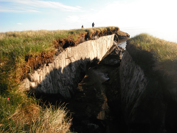
Huge Reserves of Mercury Discovered in Arctic Permafrost
View the page for this story
A new study estimates that Arctic permafrost contains some of the biggest reserves of mercury on the planet. As global warming melts permafrost, this huge pool could enter the food web and increase levels of toxic mercury worldwide. Living on Earth’s Jaime Kaiser speaks with study lead author Paul Schuster, a hydrologist with the United States Geological Survey, about the source and future of this frozen mercury. (05:41)

As Sea Levels Rise, Nantucket Shores Up Crumbling Beaches
/ Jenni DoeringView the page for this story
30 miles off the coast of New England, Nantucket Island is a historical gem and an upscale haven for summer vacationers. But erosion and rising seas are threatening some of its most expensive real estate. Living on Earth’s Jenni Doering reports that homeowners are funding an extensive engineering project – but some locals worry that it could have ecological consequences. (11:54)
The Telescope in the Ice: The Hunt for the Ghost Particle
/ Steve CurwoodView the page for this story
One of the world’s most sensitive telescopes is buried deep in Antarctic ice, searching for evidence of elusive neutrinos, tiny, subatomic particles. Writer Mark Bowen’s new book, The Telescope in the Ice: Inventing a New Astronomy at the South Pole, chronicles the decades-long project to build the IceCube Neutrino Observatory. As he tells Living on Earth host Steve Curwood, IceCube’s ability to spot where neutrinos came from provides a powerful new tool for understanding many mysteries of the universe. (14:01)
Sea Lions at Play
/ Mark Seth LenderView the page for this story
Like young humans, young sea lions love to play. Living on Earth’s explorer in residence, Mark Seth Lender, watched scores of the blubbery mammals diving through the crashing waves on an inaccessible beach far below the Pacific Coast Highway at Big Sur, and mused on their joy, and the threats they face. (02:32)
Show Credits and Funders
Show Transcript
HOSTS: Jenni Doering and Jaime Kaiser
GUESTS: Nancy Kinner, Peter Schuster, Mark Bowen
REPORTERS: Jenni Doering, Peter Dykstra, Mark Seth Lender
[THEME]
CURWOOD: From Public Radio International, this is Living on Earth.
[THEME]
DOERING: I'm Jenni Doering.
KAISER: And I’m Jaime Kaiser.
A tanker makes the first winter trip north of Russia without an icebreaker, marking a new era of polar shipping – and potential ecological disaster.
KINNER: I don’t think that we are prepared for the kinds of accidents that could happen with respect to navigation, satellites, communication, let alone spill response. All of these are threats to a very, very fragile environment.
DOERING: Also, Nantucket’s shores are fast eroding as Atlantic waves batter the coast.
BORRELLI: There’s so much energy at the coast. If you think of a cubic meter of sea water it weighs about one metric ton, so there’s a huge amount of mass in water. Now, you think, on the North Atlantic Coast, a wave will hit a beach every six seconds on average. And it’s relentless.
KAISER: That and more this week on Living on Earth – Stick Around!
[NEWSBREAK MUSIC: Boards Of Canada “Zoetrope” from “In A Beautiful Place Out In The Country” (Warp Records 2000)]
[THEME]
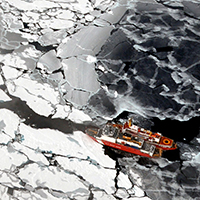
Through the Melting Arctic Seas
The thinner, less extensive sea ice in the Arctic makes ship travel much easier than historically. (Photo: Collection of Dr. Pablo Clemente-Colon, Chief Scientist National Ice Center / NOAA, Flickr CC BY 2.0)
KAISER: From PRI, and the Jennifer and Ted Stanley Studios at the University of Massachusetts, Boston, this is Living on Earth. I’m Jaime Kaiser.
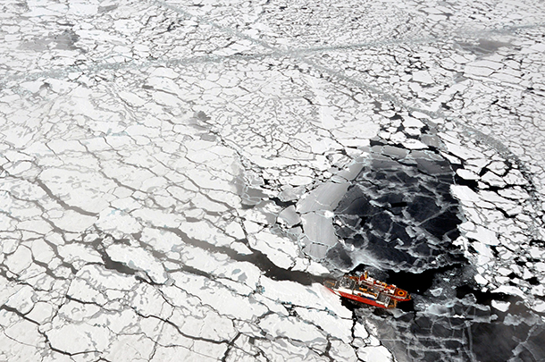
DOERING: And I’m Jenni Doering, we’re in for Steve Curwood. In December 2017, a tanker made history by sailing from South Korea to Northern Russia, where it took on a cargo of liquefied natural gas that it then delivered to France.
KAISER: What made it revolutionary was that a tanker forged a path across the top of Siberia without an icebreaker in winter. It’s a telling sign of just how much sea ice we’ve lost at the top of the world.
DOERING: To look at what this breakthrough means, we turn now to Nancy Kinner, who directs the Coastal Response Research Center and Center for Spills in the Environment at the University of New Hampshire in Durham. Nancy - welcome to the program!
KINNER: Thank you for having me.
DOERING: So, Nancy, how much of a revolution is this voyage?
KINNER: It's really a game changer in that the Russian government, in partnership with China, is trying to make a pathway for liquefied natural gas to get from the Yamal Peninsula which is kind of midway along the Russian Arctic coast to China, and to be able to do that without the escort of an ice breaker and with ice present is really a game changer.
DOERING: So, what are some of things that made it possible for this cargo ship without an icebreaker to go all the way across the top of Siberia in the dead of winter?
KINNER: Well, there is a company in South Korea that is a very large ship builder, and they basically built this ship to be able to go either in forward or reverse breaking the ice. It's able to break ice up to two meters thick, and so that is really something, especially because it's not just an ice breaker, it's a tanker.
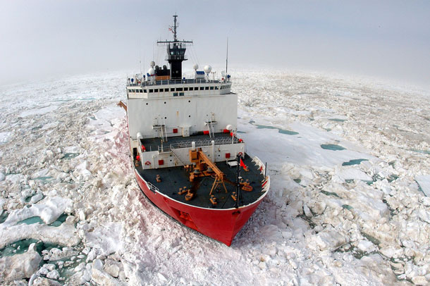
An icebreaker in the Arctic. Until last year, icebreakers were necessary to escort other ships through the Northern Sea Route. (Photo: Petty Officer Prentice Danner / U.S. Coast Guard, Flickr CC BY 2.0)
DOERING: We know that from year to year there's been a decrease in the sea ice in the Arctic. To what extent was that part of this too?
KINNER: Well, the fact that the ice is decreasing is a major player in this. So, we're getting periods of time where the waters are either with very, very broken up ice so that a ship can pass through, or no ice. We have had really relatively low amounts of ice for a good portion of January this year.
DOERING: What used to happen for ships? I think they used to have to go all the way south through the Suez Canal, right? How much shorter is this passage?
KINNER: So, this passage is about 14,000 kilometers and that is about 40 percent shorter than the traditional route through the Suez, so this can save a lot of time and money.
DOERING: So, this tanker was carrying liquefied natural gas, and of course, Russia is a big exporter of oil as well. So, what do you see as the implications of increased fuel shipping in the Arctic?
KINNER: One of the things that we have to realize is that the Arctic has very few navigational aids. There isn't a lot of satellite coverage up there. The bathymetry, what we know about the bottom, well if you don't know the depth of the water or where there might be a little mountain rising up from the bottom, boy, you could have an accident pretty easily.
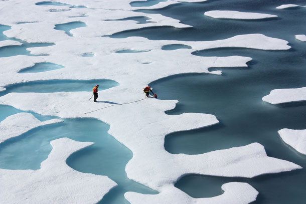
Two members of NASA’s ICESCAPE mission, a shipborne investigation researching how changing Arctic conditions affect the ocean’s chemistry and ecosystems. (Photo: NASA/Kathryn Hansen, Flickr CC BY 2.0)
The other thing is that if ships get into trouble up in the Arctic there are not a lot of other ships around to help out. The final problem is that if you do have an accident, a spill of any sort, the equipment isn't there to help clean it up. Even if you had the equipment, it's hard to get people up there. The resources are very, very fragile in the Arctic. The biota are stressed anyway because of climate change, and this puts a further stress on them to have a contaminant in the water.
DOERING: How do spills act differently in some place fairly warm like the Gulf versus some place really cold in the Arctic?
KINNER: If it's a ship disaster, there isn't a difference in necessarily how the material gets in the water. However, once the material gets into the water, that's where the differences lie in the Arctic. If the ship has been going through breaking up ice and all of a sudden there's a large amount of material released, then it can get trapped under the ice, and if the ship stops moving then the ice is going to freeze around the ship, and if material is leaking out below the water line, you now have it trapped under the ice. If it's broken up ice, then you've got to try to clean it up. In the world of ice, there's a whole ecosystem that lives at the bottom of the ice because organisms grow there, microorganisms grow there, and then other organisms come feed on those microorganisms and it's a whole food chain built around that.
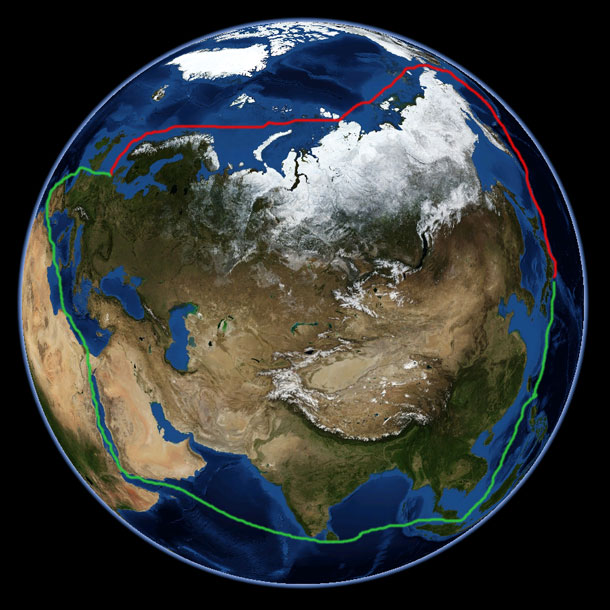
For sailing between Asia and Europe, the Northern Sea Route, shown above in red, is about 40% shorter than the Suez Canal Route, shown in green. (Photo: RosarioVanTulpe, Wikimedia Commons Public Domain)
DOERING: Gosh, that really sounds like an ecological disaster. So, in the event of gas spilling, what could that do, as opposed to oil?
KINNER: If it's released out of the bottom or the side of the ship, because it's colder, the gas is not going to just be as volatile as we would think in a warmer environment. So, it's cold in the ship, it's liquefied, and then as it's released, it's released into a cold environment so it can remain a little bit more as a liquid. Some of it will dissolve into the water, the compounds, but it can also get trapped, and some of it will obviously go up into the air if the ice is broken up.
DOERING: So, what are the possible geopolitical effects of an increase in Arctic ship traffic?
KINNER: The Arctic Ocean is a very finite space. The UN has a Law of the Sea that was created. Almost every nation has signed onto it, the US has not, and as part of the Law of the Sea, there are very very strict regulations about how countries establish their, let's think of it as dominion - what are their waters. When countries are now looking at where their boundaries are with respect to the water, they are really overlapping. The US and Canada overlap, Russia overlaps. These waters are extremely contested, so all of this has really big implications for who controls the waters that these ships are going to go through, and of course, who controls the resources that are under the sea bed. And we know that there's a lot of gas, a lot of oil, potentially under the Arctic Ocean, and so who owns that sea bed is very, very important with respect to natural resources. So, all of this is really contested and a lot of it is supposed to be settled with the Law of the Sea, and of course, the US is not a signatory, so we're kind of in a very strange space on that one.
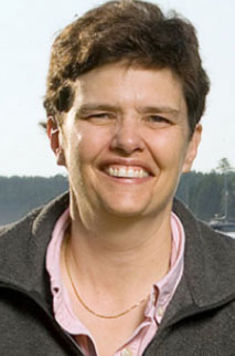
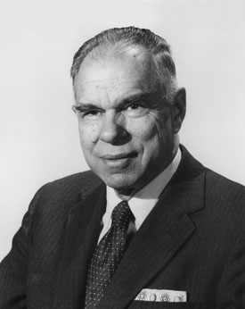
Nancy Kinner directs the Coastal Response Research Center and Center for Spills and Environmental Hazards. (Photo: University of New Hampshire)
DOERING: So, Nancy how worried are you about this increase in Arctic ship traffic?
KINNER: For the long term, I think I'm quite worried because I don't think that we are prepared for the kinds of accidents that could happen, and I mean prepared with respect to navigation, with respect to bathymetry, all of these kinds of things, satellites, communication, let alone a spill response. So, all of these are threats to a very, very fragile environment, not only an ecosystem, but also to the peoples who live in those areas. A lot of them are indigenous peoples whose livelihoods depend on subsistence from the sea. So, I'm worried. We need to get our act together here.
DOERING: Nancy Kinner directs the Coastal Response Research Center and the Center for Spills and the Environment. Thank you, Nancy.
KINNER: It's been a pleasure talking to you.
Related links:
- Coastal Response Research Center and Center for Spills and Environmental Hazards
- Our previous conversation with Nancy, about chemical dispersants and Deepwater Horizon
Beyond the Headlines
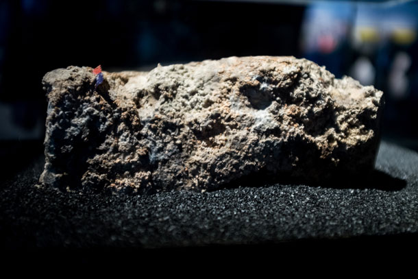
A piece of the London fatberg, the giant deposit of fats, oils and grease that clogged the city’s sewers, is on display at the Museum of London until July 1, 2018. (Photo: Seeing Sanitation, Flickr CC BY 2.0)
KAISER: We’ll take a trip beyond the headlines now with Peter Dykstra of DailyClimate dot org and Environmental Health News, that’s ehn.org. He spoke from Atlanta Georgia with Living on Earth’s Helen Palmer.
PALMER: Hi Peter, how are you doing?
DYKSTRA: Doing well Helen, how about you?
PALMER: Pretty good, what have you got for us?
DYKSTRA: Well were going to talk about fatbergs, it’s a… in this case it’s a different kind of London Fog. Fog means fats, oils and grease and that’s something that sewage workers fear, the fatberg is something that was scraped and blown with high pressure water hoses off the inside of London’s sewer tunnels. There was a piece 130 tons, congealed fat poured in from household drains and poured in from restaurants and other sources, combined with other things like hand wipes, that was beginning to clog pipes. And it’s become a huge problem but also a museum exhibit!
PALMER: Really? People want to see this thing?
DYKSTRA: In the Museum of London there’s now a chunk of the fatberg on display, it’s there until July 1st, it’s drawing big crowds and I guess as far as fatbergs go, rave reviews.
PALMER: Well I can’t imagine why anyone would want to see it but I suppose we do need to face what we do to the sewers.
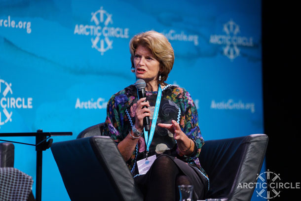
Senator Lisa Murkowski of Alaska, who has long been a proponent of oil drilling in her state, recently spoke about how Republicans need to pay more attention to climate change. (Photo: Arctic Circle, Flickr CC BY 2.0)
DYKSTRA: That’s right and it’s not just in London. They’ve found them in Australia, there was one in Baltimore this past year that actually caused a sewage spill when it completely clogged a pipe. Think of it as a clogged artery in a human being. It works that way, it costs money, it causes sewage spills and it’s just kind of gross.
PALMER: So it’s just obviously a good reminder to us not to put those fats down the drain.
DYKSTRA: Right and it is a consumer thing too. Because even though some of the biggest culprits are institutions or restaurants, we contribute when we put fats, oils and grease in our own drains and into our own sewer systems, not only harming the big sewer system, it can cause problems with your own pipes, in your own home, and that costs money.
PALMER: Well, that’s enough about the fatberg, what else have you got?
DYKSTRA: Lisa Murkowski, the Alaska senator who has been gung-ho on oil, has decided that she’s a little bit gung-ho on something else. She delivered a speech in Washington last week in which she said her fellow Republicans have to pay attention to climate change. And obviously Alaska is ground zero for the impacts of climate change. Senator Murkowski wants to keep drilling, though, she wants to have her oil cake and eat it too.
PALMER: Yes, it doesn’t seem to fit together that you’ve got all this melting permafrost in Alaska and disappearing villages and she wants to actually continue promoting drilling, or in fact open up ANWR to drilling.
DYKSTRA: Yeah, it’s a bit of a contradiction and not the first one from a famous Alaska politician. About a decade ago, there was an Alaska governor who set up a Climate Change Sub-Cabinet and that governor was Sarah Palin, who went on to national fame, and went onto reality TV and then went on to complete climate denial.
PALMER: So what happened to her Climate Sub-Cabinet?
DYKSTRA: It sank into the melting permafrost, it never met, it’s never been heard from again, but at least she had that idea before changing her idea.
Chemist Glenn Seaborg, a Nobel Prize recipient, created plutonium in 1941, laying the groundwork for the nuclear arms race. (Photo: United States Department of Energy, Wikimedia Commons public domain)
PALMER: [LAUGHS] So what history lesson do you have for us today?
DYKSTRA: We’re gonna wish a Happy Birthday to plutonium! Back in 1941, Glenn Seaborg and a team of chemists and scientists at the University of California Berkeley, developed the element plutonium. They did so in a university building, in an urban campus, in a third floor attic lab, in the middle of a city.
PALMER: Yeah, I hadn’t known about Glenn Seaborg until I read about him. He’s a really big deal in nuclear physics.
DYKSTRA: Right, he later shared a Nobel Prize in Chemistry and was a big part of the Manhattan Project, once he had developed plutonium. The U.S. was on its way to developing, eventually the plutonium bomb that was a key part of the arms race.
PALMER: Thanks, Peter. Peter Dykstra is with ehn.org, Environmental Health News .org, and dailyclimate.org. Thanks a lot, we’ll talk to you soon!
DYKSTRA: Ok Helen, thanks a lot.
DOERING: Peter Dykstra with Living on Earth’s Helen Palmer and there’s more on these stories at our website, loe dot org. And there’s more on these stories at our website. LOE dot org.
Related links:
- The Guardian: “Don’t feed the fatberg! What a slice of oily sewage says about modern life”
- The Center for Climate Strategies: “Governor Palin signs administrative order creating the Climate Change Sub-Cabinet”
- Encyclopædia Britannica: “Glenn T. Seaborg”
[MUSIC: Because Of a Drum and a Song”]
KAISER: Coming up, How the coast of Nantucket Island is slip-sliding away. That’s just ahead on Living on Earth, keep listening!
ANNOUNCER: Support for Living on Earth comes from the Gordon and Betty Moore Foundation, and from a friend of Sailors for the Sea, working with boaters to restore ocean health.
[CUTAWAY MUSIC: “The Sinister Minister”]
Huge Reserves of Mercury Discovered in Arctic Permafrost
Researchers estimate there is enough mercury in Arctic permafrost to fill 23 Olympic swimming pools. (Photo: Brandt Meixell, USGS, Public domain)
DOERING: It’s Living on Earth, I’m Jenni Doering.
KAISER: And I’m Jaime Kaiser, we’re in for Steve Curwood. Temperatures are rising twice as fast in the Arctic as the world average, and that means that permafrost, the once permanently frozen soil of high latitudes is becoming – well, less permanent.
DOERING: As it melts, greenhouse gases like methane and carbon dioxide escape, adding to the warming. And now new research shows huge reserves of toxic mercury are also trapped in arctic permafrost and they’re at risk of escaping too.
KAISER: Paul Schuster is a hydrologist from the United States Geological Survey, and lead researcher on the study. Paul, welcome to Living on Earth.
SCHUSTER: Oh thank you for having me.
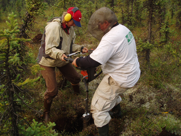
Researcher Kim Wickland (left) and Paul Schuster drill a permafrost core sample in Coldfoot, Alaska. (Photo: courtesy of Paul Schuster, USGS)
KAISER: Of all the things that you could have studied about permafrost, why did you choose to study mercury?
SCHUSTER: Mercury is a ubiquitous pollutant throughout the globe, and it's somewhat different than the other pollutants we're used to hearing about in the news. Mercury's a different beast in many ways and the mercury is always moving, it's always cycling. It's been doing it though on a geologic time scale, and that's OK because the Earth can adapt at a geologic time scale, but we are affecting that geologic time scale right now. We are -first of all, we're introducing much more mercury into the atmosphere, and so that's one part of the equation. The other part is that we are warming the Earth too.
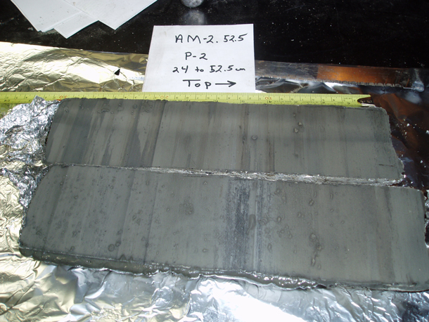
Scientists collected 13 Arctic permafrost cores like this one. The striations in this cross-section represent thousands of years of geologic time. (Photo: courtesy of Paul Schuster, USGS)
As the Earth warms, that energy thaws the permafrost. Now, that has happened before in the past as natural processes with ice ages and interglacials and glacials, but they were on scales of thousands to hundreds of thousands of years. The permafrost that is thawing right now, all the models predict that by the year 2100, 30 to 99 percent of our permafrost will be thawed, and we think that that's going to be a problem for ecosystems because baseline mercury is going to increase so fast that things can't adapt to it.
KAISER: So, where did you get your data about mercury in the permafrost?
SCHUSTER: We cored the permafrost. We had coring devices that took cores up to about a meter in length and about four centimeters in diameter, and we pulled those cores out and we kept them frozen. We brought them back to our laboratory and then we sliced them up into little slices, about one and a half centimeters thick. And each one of those slices we processed very carefully because mercury is also very easy to contaminate.
KAISER: And so how much mercury did you find?
SCHUSTER: Well, when you add it all up, it was a lot more than we thought it would be. We added up all our cores, and the cores we took were representative of - of many diverse depositional environments, all in the northern hemisphere. So, we had a representative data set that we could upscale to the rest of the north, and bottom line was we added it all up. The pool of mercury in permafrost is about 793 gigagrams, so 793 gigagrams is 23 Olympic size swimming pools.
KAISER: Wow, so this is a lot of mercury. How did all this mercury get trapped there in the first place?
SCHUSTER: It's a natural process, believe or not. Part of the global cycle is atmosphere, atmospheric deposition, and it gets there by natural processes, at least before industrial revolution. Most of it was volcanic or geologic in origin, and that mercury gets a continuous deposition, so it just builds and builds over the millennium since the last ice age.
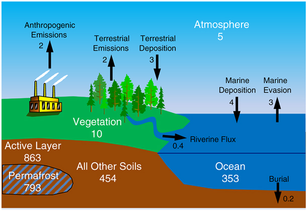
A schematic of the modern mercury cycle shows updated mercury concentrations based on the study’s findings. Major reservoirs are in white (gigagrams of mercury) and fluxes in black (gigagrams of mercury per year). (Photo: courtesy of Paul Schuster, USGS)
KAISER: It's my understanding that mercury is non-reactive and not that dangerous unless ingested directly, but what's the danger of mercury once it gets into the food web?
SCHUSTER: Right, right. What we need to understand is what was - is called methylation. When the mercury gets into the soil as elemental forms, there is bacteria in the soil they have a process by which they reduce sulfur and carbon to make it make energy and in turn, there's a byproduct. If mercury is present in that -- during that metabolizing process, mercury will get a CH3 molecule attached to it and that's called methylmercury. And that form of mercury can enter living tissue, and it does, and as it enters living tissue and goes up the food chain it bioaccumulates and biomagnifies. Where you have the lower end of the chain is where mercury levels are the lowest and typically not harmful in their concentrations, but as methylmercury moves up the food chain it gets more and more concentrated and it becomes toxic and the higher forms of life in the food webs like the fish, the birds, and us can get toxicity if it gets too high.
KAISER: And so does your team have any idea about how much mercury you expect to be released and when?
SCHUSTER: No, we don't, and that is the next step, OK? And we're actively doing that right now. We need much more data basically. We hear scientists say that all the time but in this case it's really true because we had thirteen cores, and during the review process we were criticized heavily that those thirteen cores cannot adequately represent the rest of the Northern Hemisphere. So, what do we need to do? We need to go out and get more cores from many different parts of the Northern Hemisphere and add that to our dataset to expand it.
KAISER: Paul Schuster is a hydrologist with the US Geological Survey and lead author of the study. Paul, thank you so much for taking the time today.
SCHUSTER: Thanks for having me, and it was a pleasure to speak with you.
Related links:
- Original study published in Geophysical Research Letters: “Permafrost Stores a Globally Significant Amount of Mercury”
- The Washington Post: “The Arctic is full of toxic mercury, and climate change is going to release it”
- Mercury in the Environment Fact Sheet from the U.S. Geological Survey
[MUSIC: Darshan, “Animate My Anatomy” on Raza, Chant Records]
As Sea Levels Rise, Nantucket Shores Up Crumbling Beaches

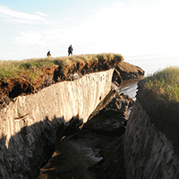
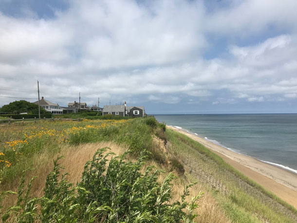
'Sconset’s Baxter Road neighborhood, including Sankaty Head Lighthouse at its northern end. Erosion has been especially rapid in past decades along this stretch of the Nantucket coast. (Photo: 'Sconset Beach Preservation Fund)
DOERING: Thirty miles off the coast of New England is an island that the National Park Service calls the “finest surviving architectural and environmental example of a late 18th-and early 19th-century New England seaport town.” Back then, Nantucket grew rich on the spoils of the whaling industry. And even after petroleum put that industry out of business, much of the island’s elegant wharf-side architecture remained.
[OCEAN WAVES SFX START FADE IN; GULLS CALLING (link to audio uploaded by Freesound.org user juskiddink)]
DOERING: Today, Nantucket is a popular summer colony, and the historic homes have been joined by newer, but still tasteful, construction – in places no one would have built back in the whaling days. At the east end of the island is Siasconset – locals call it simply, ’Sconset. Its multi-million-dollar cottages have stunning views directly facing the great Atlantic, where it comes ashore in its full ferocity.
[OCEAN WAVES]
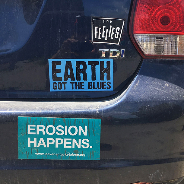
A bumper sticker seen on the island. (Photo: Jenni Doering)
DOERING: So the very bluff on which they are built, and the beaches below, are under assault, says Mark Borrelli, a coastal geologist at UMass Boston.
BORRELLI : There’s so much energy at the coast. If you think of a cubic meter of sea water it weighs about one metric ton, so there’s a huge amount of mass in water. Now, you think, on the North Atlantic Coast, a wave will hit a beach every six seconds on average. And it’s relentless.
DOERING: Standing on the beach, facing the open ocean on the Nantucket shore, I could feel this energy as a wave curled over and crashed down.
[OCEAN WAVES CRASH LOUDLY]
DOERING: And these powerful waves are slowly eating away at the island.
BORRELLI : Nantucket and parts are getting smaller...for the most part, yeah, you’re losing land on Nantucket.
DOERING: It’s not just the energy at the coast that’s to blame; rising seas caused by climate change, and the island’s geology, are also part of the problem.
BRACE : We’re very very vulnerable here. We’re not the rocky coast of Canada or Maine or Oregon. We’re sand.
DOERING: Peter Brace is a naturalist. At ’Sconset, that sand holds up dozens of summer homes: big, sturdy cottages, covered in gray cedar shingles that keep out the fierce storms that pummel Nantucket. But Josh Posner, the President of the ’Sconset Beach Preservation Fund, says they’re no match for the erosion that’s creeping closer to their foundations.
POSNER: The edge of the bluff has moved back towards the road that is behind the houses, in a lot of the places 100 feet of the lot has now collapsed so what used to be a 150-foot lot is now 50 foot or even in some cases less.
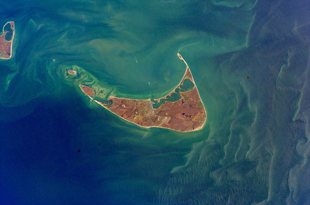
Nantucket is shaped rather like a porkchop, thanks to winds and waves sculpting it over thousands of years. (Photo: NASA Johnson Space Center – Earth Sciences and Image Analysis (NASA-JSC-ES&IA)
DOERING: Posner and his neighbors aren’t just sitting back and waiting for the waves to carry their property out to sea.
POSNER: Where do you make a stand and how do you make a stand, in order to protect what we’ve built and protect our civilization?
DOERING: After trying a few different ways of shoring up the bluff over the years, with limited success, Posner and his deep-pocketed neighbors decided in 2013 to try something on a much larger scale. From the modest cottage she rents at ’Sconset, Marianne Kelley has watched this latest project unfold.
KELLEY: I know they were trying to do it from the base of the bluff, which is where they were doing um, the jute, filling the jute sand bags; I call them sand burritos.
DOERING: They’re actually called geotubes, and indeed they do look a bit like giant burritos! 200 feet long, seven and a half feet tall, and 20 feet wide, the geotubes line the bluff for 1000 feet and are stacked at an angle, four high. Marianne Kelley invites me to her front-row-seat view from the edge of her backyard – the very edge – just seventeen feet from her house.
[SOUND OF WAVES]
KELLEY: Yeah, does this scare you?
DOERING ON TAPE: Well, it it does feel like on the edge.
KELLEY: ’Cause some people can’t, they can’t go very close. I’m used to it now.
Peter Brace is a Nantucket naturalist who leads natural history walks around the island. (Photo: Jenni Doering)
DOERING: From Kelley’s backyard, I can’t actually see the geotubes themselves: they’re covered with sand, to return the engineered bluff to a state as close to natural as possible. Far below, the waves crash onto a narrow beach.
[MORE WAVES]
DOERING: The geotubes that defy the force of those waves are designed to stay firmly put. But the sand that covers them is dynamic. Again, Peter Brace.
BRACE: Waves that are breaking on the shore are taking sand into the water, and a current carries the sands, the sediments, along the shore in one direction or another.
DOERING ON TAPE: Nantucket itself is -- it is kind of shaped like a horseshoe, or maybe like a boomerang.
BRACE: Or a porkchop.
DOERING ON TAPE: Or a porkchop! That’s a great way of putting it.
DOERING: In fact, (perhaps like your dinner), the island came straight out of a gigantic freezer: a massive ice sheet that covered much of North America 25,000 years ago.
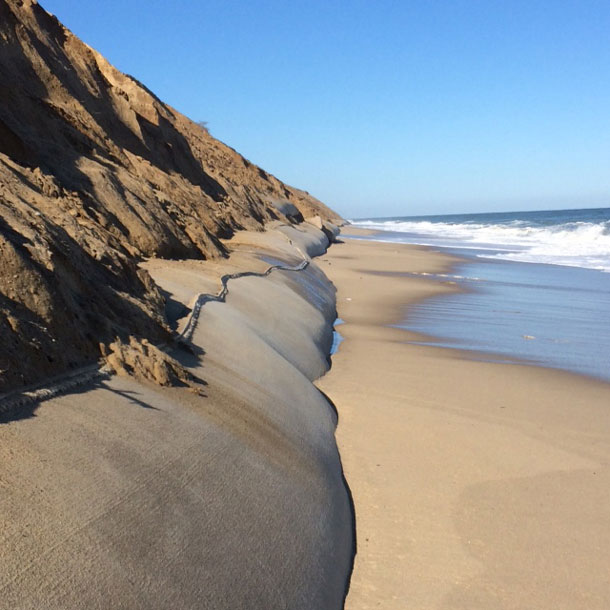
Winter Storm Jonas in January 2016 brought crashing waves that uncovered the geotubes, before more sand was added back on top. (Photo: 'Sconset Beach Preservation Fund)
BRACE: The Laurentide Ice Sheet covered all of Canada at one time, and then covered the top northern one-third of the U.S. almost out to the west coast.
DOERING: And Brace says this gargantuan block of ice was a powerful geologic force that shaped the land as it moved.
BRACE: You have to kind of look around you and see what you see here, didn’t exist. It didn’t exist yet. It was just, it was the coastal plain. And the material got pushed here.
DOERING: What got pushed there was a lot of sand – and Emily Molden says for thousands of years, it’s been in motion, driven by the forces that the geotubes are designed to resist.
MOLDEN: And that sand doesn’t just disappear. It’s going somewhere. It has a destination. So it’s serving as a sediment source to other beaches, to other sandbars, other shoals.
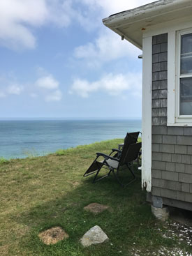
Marianne Kelley’s ’Sconset cottage has a great view – but not much backyard before the drop-off. (Photo: Jenni Doering)
DOERING: Molden’s the resource ecologist for the Nantucket Land Council, a land trust and watchdog group.
MOLDEN: We are especially concerned about the geotubes constructed in ’Sconset because that’s really a ground zero for erosion on the island. By preventing that sediment from eroding out of the bluff, you’re starving those down-gradient areas and systems from sand that they would naturally be receiving.
DOERING: That’s one reason why the geotubes must be covered with sand at all times – so that nature still has something to work with. Josh Posner again.
POSNER: We add on top of our geotubes the amount of sand that historically has washed away in the natural erosion process. And so, the system is covered with sand almost all of the time.
DOERING: But only almost all the time, because in the fiercest storms like powerful Nor’easters, the sand covering the geotubes gets washed away. That happened just this January 2018, when a massive Nor’easter brought record high tides and flooding to Nantucket and the rest of New England. So after such a storm, the ’Sconset Beach Preservation Fund brings in the dump trucks, carting material from sand pits elsewhere on the island.
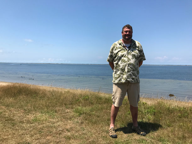
Josh Posner in his Cambridge, Massachusetts home. (Photo: Jenni Doering)
That effort, like the geotubes, is funded by the homeowners at ’Sconset Bluff. Emily Molden says it’s good that sand covers the geotubes most of the time – but she doubts it can last.
MOLDEN: That sand is becoming more and more expensive. And the greater the extent of a structure like the geotubes, the more sand is necessary. Now, I think that you’re looking at a structure that has a pretty long lifespan, probably decades. So it’s just hard to say going forward whether that interest and funding will continue.
DOERING: Re-covering the geotubes might need to happen even more frequently in the near future, as climate change brings rising seas and nastier storms. Since Nantucket is a ways offshore, storms are already quite fierce in the wintertime. Unlike many of her neighbors who only summer on Nantucket, Marianne Kelley lives in her small cottage year-round.
KELLEY: I’ve been here in the winter and I’ve been through a lot of the storms and I’ve seen, you know, glass fall off our shelves, our house shakes in the heavy winds -- we get over 100 miles an hour here. I always joke around that I’d bungee cord myself to the nearest telephone pole in a storm, but in really big storms I don’t stay here.
DOERING: Some of her neighbors joke about the situation, too – houses here have names like “House of Cards” and “Slip-Slide-N-Away.” Down the road from Kelley, neighbor Loretta Yoder’s backyard is really slip-slidin’ away – often without warning.
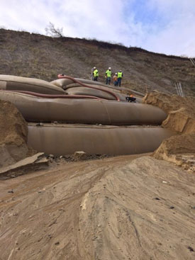
The geotubes during installation. (Photo: ‘Sconset Beach Preservation Fund)
YODER: I went for a walk on a sunny day like this and when I came back a chunk – a one- or two-foot chunk from the edge – had fallen down.
DOERING: Usually, nature sculpts more gradually, and Yoder has spent years observing this slow process.
YODER: The bluff wants to find what they call its comfort angle of repose, which is an angle where plants and dirt can hold on. With a bluff, with a dirt bluff that’s not planted, you’re going to always have some attrition.
[SOUNDS OF WIND; RAIN & TRICKLING WATER; WAVES]
The wind takes it away, the rain makes little rivers. And if the waves come in and eats away at the toe, that goes back and then the top dribbles down to match that.
[WAVES CRASH LOUDLY]
DOERING: After that chunk of earth fell away from her backyard, Yoder and her partner decided to move their house thirty-four feet back from the edge.
YODER: It was getting to the point where… it just felt like if we wanted to stay in a place and that it was secure we needed to do it.

In the summertime, Loretta Yoder throws open the garage door of her ‘Sconset home and paints in her makeshift studio and gallery. Geotubes don’t yet line the bluff below her home, which is threatened by erosion, but a proposal to expand the existing project would extend them to below her property. (Photo: Jenni Doering)
DOERING: But at some point, you just run out of room. And Yoder’s part of the bluff isn’t shielded by geotubes. The ’Sconset Beach Preservation Fund wants to change that.
Josh Posner took the first step in January 2018 by submitting a proposal to expand the geotubes from the current 1000 feet to nearly 4000. He says it’s not just an engineering challenge – it’s also a moral issue.
POSNER: You know, our job as people is to use common sense and judgement about what makes sense and what doesn’t, and where it makes sense and where it doesn’t. So, I know there’s people who feel that the only responsible thing to do in our situation is to abandon our homes and let erosion take its natural course. I don’t happen to agree with that.
DOERING: That choice about whether to engineer solutions to erosion and sea level rise – or, to retreat -- now faces coastal communities everywhere.
[DISTANT WAVES]
DOERING: Sea levels are predicted to rise two to seven feet in this century. And remember: this island is nothing more than loose, sandy material; no match for powerful waves and rising seas, says Nantucket ecologist Peter Brace.
BRACE: We’re right where it’s going to happen. We’re gonna go underwater before a lot of the coastline.
DOERING: In the meantime, Loretta Yoder keeps a close eye on the bluff edge in her backyard.
The bluff has been replanted with native grasses to help hold the eroding sand and soil in place. (Photo: Jenni Doering)
YODER: We put a little log up on the edge and we wait and see how long it takes for that little 5-inch piece of wood to not have any support under it and fall down.
DOERING: And what works or doesn’t work to hold back the sea on this tiny island may hold valuable lessons for coastal communities everywhere. In the meantime, the sea that’s sculpted Nantucket over thousands of years continues to push and pull sand -- shaping the shore, and the lives of the people on this little pork chop of an island.
[SOUNDS OF WAVES]
DOERING: And Jaime, I had a lot of help with this story! – I owe thanks to Living on Earth’s Matt Hoisch and Rebecca Redelmeier.
KAISER: Yes our whole team was on Nantucket – we had a great time and next week, I’ll be reporting on its crab populations.
Related links:
- 'Sconset Beach Preservation Fund
- Nantucket Land Council
[MUSIC: MARgot Chamberlain, “Ay Ondas (Waves Of the Sea)” on Golden Threads-Harp and Song, from Martin Codax, 13th c. Galician, www.margotchamberlain.com]
DOERING: Coming up, the search for the elusive “ghost particle” – the neutrino. That’s just ahead here on Living on Earth, stay tuned.
ANNOUNCER: Funding for Living on Earth comes from you our listeners, and United Technologies - combining passion for science with engineering to create solutions designed for sustainability in aerospace, building industries and food refrigeration. UTC companies such as Otis, Carrier, Pratt & Whitney and UTC Aerospace Systems are helping to move the world forward. You can learn more about United Technologies by tuning in to the Race to 9 Billion podcast, hosted by UTC’s Chief Sustainability Officer. Listen at raceto9billion.com. That’s raceto9billion.com. This is PRI, Public Radio International.
[CUTAWAY MUSIC: Margot Chamberlain, “Ashokan Farewell” on Golden Threads-Harp and Song, composed by Jay Ungar, www. margotchamberlain.com]
The Telescope in the Ice: The Hunt for the Ghost Particle
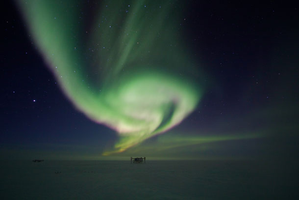
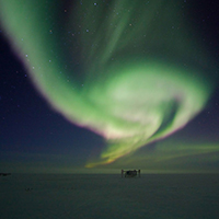
The aurora australis or Southern Lights produce different colors based on where electrons that enter our atmosphere encounter atoms of oxygen and nitrogen. Both the type of atom and the altitude affect the color that we see. Here a colorful aurora swirls above the IceCube Lab. (Photo: Keith Vanderlinde, NSF)
KAISER: It’s Living on Earth, I’m Jaime Kaiser.
DOERING: And I’m Jenni Doering, we’re in for Steve Curwood. Ever since Galileo turned his telescope towards the heavens four centuries ago, these finely tuned instruments have produced breathtaking images – of planets, and other galaxies.
KAISER: But one of the most exciting new telescopes doesn’t “look” at anything at all, in the traditional sense. The IceCube Neutrino Observatory is made up of thousands of light detectors, buried in a cubic kilometer of diamond-clear ice at the South Pole.
DOERING: It’s searching for neutrinos – tiny, almost massless subatomic particles that can pass through a light-year of lead without slowing down, and perhaps they can even shed light on how our universe formed after the Big Bang 13.8 billion years ago.
KAISER: The telescope’s creation story is also an epic tale that writer Mark Bowen captures in his book The Telescope in the Ice. He spoke with Living on Earth host Steve Curwood.
CURWOOD: So, IceCube is designed to detect neutrinos, sometimes called ghost particles. So, in layman's terms, what exactly is a neutrino?
BOWEN: It is an elementary particle, that means I don't think it can be broken up into anything else. It's a very basic constituent of matter and it's really odd and very hard to detect. It was, interestingly, one of the first elementary particles to be discovered. The only ones that were known in 1930 when Wolfgang Pauli had this incredible feat of kind of insight and intuition were the proton, the photon, and the electron. And the strange thing about the neutrino is that even now nobody understands it very well, and it's one of the forefronts of particle physics because it just is this really weird particle.

The IceCube Neutrino Observatory instruments a volume of roughly one cubic kilometer of clear Antarctic ice with 5,160 digital optical modules (DOMs) at depths between 1450 and 2450 meters. The observatory includes a densely instrumented subdetector, DeepCore, and a surface air shower array, IceTop. (Image: IceCube Collaboration)
CURWOOD: Why is science so fascinated with the neutrino? What is it that we're trying to understand, do you think?
BOWEN: For two reasons, first of all, it will help explore the universe, explain the behavior of these incredibly strange things that are being discovered far off in outer space. We have now entered this era called multi-messenger astronomy. We saw this merging neutron star event which resulted in a gravitational wave, and it was also seen with light. The neutrino would be yet a third messenger besides light and gravitational waves with which we can look at these exotic things like merging neutron stars or blazars, these incredibly bright galaxies off in the cosmos and things of that sort.
So, it's an astrophysical tool, and the neutrino has so far revealed the only physics beyond the standard model of particle physics. So, back in the 1970s, people like Steven Weinberg, Sheldon Glashow, Abdus Salam, put together something called the standard model which explains by now all the known elementary particles.
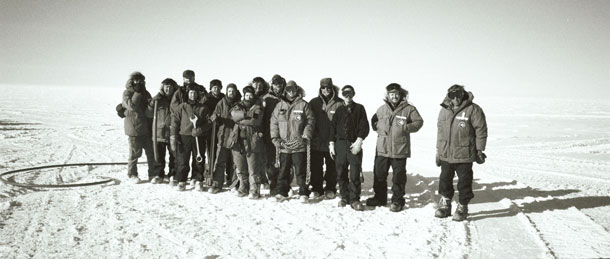
Members of the AMANDA (Antarctic Muon And Neutrino Detector Array) drilling crew in the millennial season of 1999-2000. “Master driller” Bruce Koci stands at the far right. (Photo: Mark Bowen, AMANDA/NSF)
The last one that was discovered was the Higgs boson to great fanfare in 2012. Well, it's getting a little bit scary now because the standard model works so well that it's beginning to feel like a straitjacket. It seems like people have discovered everything they can -- that they can discover and scientists don't like that. They like to discover new things, but the neutrino has actually revealed some physics beyond the standard model. The standard model says that it should not weigh anything and an experiment very much like IceCube showed in 1997 that neutrinos have mass. So, right now there are probably a billion or more dollars worth of research efforts aimed at trying to explore the neutrino to see if they can uncover new physics that might lead to, oh, just new beauty in the universe really. I mean, basic science is exploration at its heart.
CURWOOD: Talk to me about the basic design of the IceCube and how on Earth it's supposed to be able to detect these tiny particles that are...they have mass, but barely apparently.
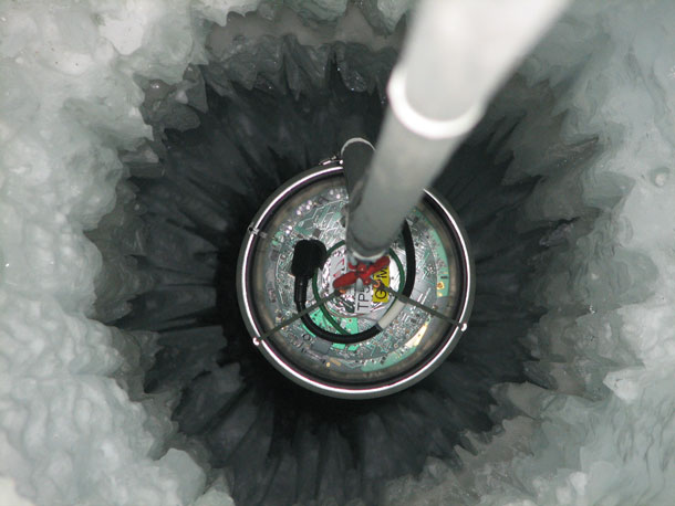
The deployment of each of the 86 IceCube strings lasted about 11 hours. In each one, 60 sensors (called Digital Optical Modules, or DOMs) had to be quickly installed before the ice completely froze around them. (Photo: IceCube/NSF)
BOWEN: The key to detecting one at least in this case is to monitor some huge volume of some clear material and watch for an interaction of the neutrino...a neutrino with that material. What happens is, when a neutrino interacts with either a proton or a neutron, something in the nucleus of any atom at all, or molecule, it disappears and knocks out a particle that gives off light that can be seen. So, you don't actually look at the neutrino itself, you look at the product of the neutrino’s demise and that particle is knocked out just like -- as if you hit a billiard ball head on with a cue ball, gets knocked out of that nucleus going in pretty much exactly the same direction as the neutrino was going in.
A neutrino can produce three kinds of particles, but the basic one, the workhorse is called a muon, which is just like an electron, but it happens to weigh more and it has some other slight differences. The muon will speed through the ice or you can use water or you can use air. It has to be clear because you have to see the light that it's giving off. It's actually going faster than light can travel in that medium. It's not breaking Einstein's postulate of special relativity that nothing can travel faster than the speed of light. It is travelling about the speed of light but light itself would go slower because that medium has an index of refraction. So, therefore, what happens is it drags a cone of light behind it because the light can't keep up with it. It's just like a boat on a lake. The reason that the waves come off in an angle behind the boat is that the waves can't go as fast as the boat, and that's exactly what's happening except it's three dimensional.
So, this thing is zooming through the ice and it's dragging this cone of -- of light behind it, and what the IceCube scientists have done is drilled deep, deep holes, a mile and a half, or a mile and three-quarters deep in the incredibly clear ice at the South Pole, and dropped into them these strings of pearls, these basketball sized light detectors, and they've created this three dimensional grid of light detectors in the ice. And since that muon is traveling in the same direction as the neutrino was, you have a telescope, you can see where the neutrino came from, you can point back and see what object might have created that neutrino.
CURWOOD: So, Mark, if you just need a clear medium, why not use water? Why not use air? Why go to the South Pole and drill a mile and a half in the ice and, you know, that's not exactly the easiest place to work, the South Pole.
BOWEN: Yes, very good question. As it turns out, amazingly, the South Pole is a very easy place to work compared to the ocean because you don't have waves, because you can walk on your experiment, because you don't have to deal with ocean engineering, and in fact, the first valiant and pioneering attempt to do this was off the coast of the big island of Hawaii. They tried for something like 14 years and failed because, largely, of the difficulties of deploying these same sorts of strings of detectors on the ocean floor, and so it turns out to be cheaper, they tried this project in Hawaii, they had been going for something like 10 years or 11 years by the time the project that is now IceCube, it was then known as AMANDA, the Antarctic Muon and Neutrino Detector Array. They began trying to deploy strings in the ice in 1991, and they actually succeeded in having a semi-working instrument by 1993, in like two or three years, whereas the Hawaiian project even after 11 years hadn’t put a string on the bottom of the ocean.
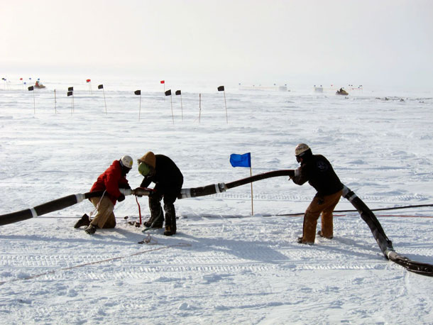
Members of the drilling crew working on the hose that carried hot water across the ice from the heating plant to the IceCube drill. (Photo: IceCube/NSF)
CURWOOD: And tell me why the atmosphere isn't a great place to try to detect these neutrinos from outer space?
BOWEN: So, both IceCube and this Hawaiian attempt which was called DUMONT, the Deep Underwater Muon and Neutrino Detector are buried like a mile deep in the water or the ice. The reason is that you use that overburden, what's above the instruments as a shield because right now, Steve, you and I have zillions of cosmic ray particles zipping through our bodies and into the Earth. IceCube is buried more than a mile deep in the ice in order to block or attempt to block those particles. Some of them still punch through all the way down a mile deep. So, the instrument is actually designed to look the other way. If you're standing on the South Pole, the instrument looks down. It's looking for muons coming up from what would be the northern sky. It is looking for neutrinos that have made it all the way through the Earth and then happen to interact with the ice right near the detector or even the bedrock below it, and set a muon zooming through the detector.
CURWOOD: So, IceCube and its predecessor AMANDA, that Antarctic Muon and Neutrino Detector Array that you described, required actually drilling holes hundreds and well thousands of meters deep into Antarctica's ice. How on Earth did the master driller and his name is Bruce Koci and his team accomplish this in such a hostile environment?
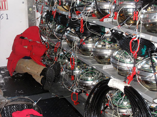
An exhausted IceCubist catches a nap in the drilling and deployment building, next to a rack of IceCube DOMs ready to be dropped into the ice. (Photo: IceCube/NSF)
BOWEN: Bruce was capable of dealing with hostile environments. [LAUGHS] I tell the story about when they first met him because they did a test hole in Greenland back in 1990 or something like that, Bruce would sleep outside it in an unheated tent on the summit of Greenland 10,000 feet high. You had this kind of intuitive almost shamanistic knowledge of ice that Bruce Koci had from decades of drilling ice cores and doing hot water drilling which is what IceCube uses, and basically they just stuck their nose into it, made a bunch of mistakes and learned as they went along. They also had to deal with whether they had enough funding and enough support, so sometimes they had to compromise on the drill just because they couldn't get enough money to build the one they really wanted to build, and you know the first drill they tried actually got stuck in the ice.
So, then they go back two years later and they have a successful drilling season, and then they slowly work themselves down deeper and deeper into the ice and the first time they got really deep into the ice I think it took 12,000 gallons of fuel and it probably took them five days or a week to drill the hole, and by the time they were drilling the 86 holes they needed to drill for IceCube, I think they could drill a hole in something like 24 hours and they used only something like 3,000 gallons worth of fuel. So, over time you just learn and you just hone it and it's a real team effort.
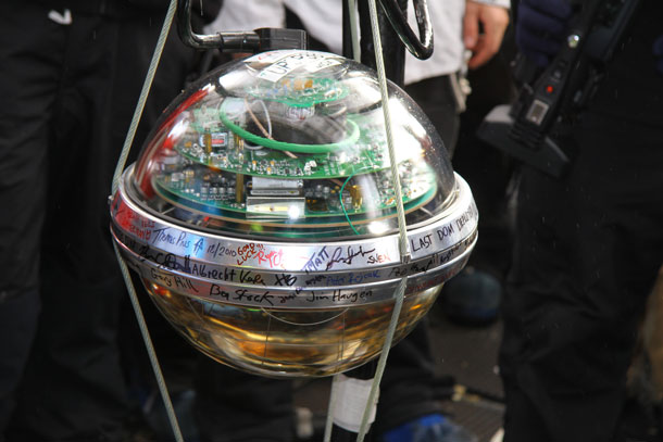
Scientists, engineers and drillers working on the deployment of IceCube in December 2010, signed the last DOM before it was buried one mile deep in the Antarctic ice. (Photo: Robert Schwarz, NSF)
CURWOOD: Talk to me about the moment that somebody actually saw one of these neutrinos from outer space, not locally produced by cosmic rays dancing around in our atmosphere. Talk to me about that moment and what that was like.
BOWEN: That was a very interesting moment. First of all, I think it happened in 2011. So, they had been working on this for 14 years at that point since it began in 1987, the experiment. And it was a Japanese woman by the name of Aya Ishihara at the University of Chiba in Japan. She had been working on IceCube for a long time, several years. So, she was looking for a very high energy kind of neutrino that comes from very high energy cosmic rays bouncing off the cosmic microwave background. They are thousands of times more energetic than any particle that could be created at the Large Hadron Collider. Of course, she was looking down into the earth. She was looking at the northern sky.
What happened was two incredibly high energy neutrinos snuck past the filters she was using to find the particles she was looking for, and they came from the southern sky. So, it was a total surprise. It was a mistake. Her filters weren't good enough, and when they looked closely at those two neutrinos, they realized that they had to be coming from outer space. They named them Bert and Ernie after the two Muppet characters.
[CURWOOD LAUGHS]

“Ernie”, the highest-energy neutrino observed to date, explodes inside IceCube. Since the entire detector is about a kilometer on a side, “Ernie” would have more than filled a professional football stadium. (Image: IceCube Collaboration)
It was a graduate student in Wisconsin who did that because you know they had some absurdly long number attached to them because each event has a number attached to it, and they just studied those things up the wazoo. You know, you had 200 physicists going crazy about what these things were. So, as with so many great things in science and in physics, they had been working for 14 years looking at the northern sky, and the first neutrinos that they detected from outer space snuck in from behind their telescope and came from the southern sky. And so then they totally reoriented themselves and started looking at these things and they've since found dozens and dozens more. And that was really the experiment that showed that they now can detect unequivocally neutrinos coming not from our atmosphere, which is kind of like the background light created by cities makes it hard to see stars, we have the same problem with neutrinos, but from the cosmos somewhere. And Aya says, you know, it was like the greatest experience of her life, this is what physicists and scientists live for, discovering new things looking at how the universe works, brings us out of ourselves and makes our minds bigger somehow. The thrill of the chase and then suddenly having the surprise which just blows your mind.
CURWOOD: Mark Bowen’s PhD is in physics, but he's now a writer and his new book is called, "The Telescope in the Ice: Inventing a New Astronomy at the South Pole." Mark, thanks so much for taking the time with us today.
BOWEN: Thank you, Steve, it's been a pleasure.
Related links:
- The Telescope in the Ice: Inventing a New Astronomy at the South Pole
- IceCube Neutrino Observatory
- Mark Bowen’s blog “Tipping Points: Science and Writing in a Changing World”
- WATCH: “What is a Neutrino?” by MinutePhysics
[MUSIC: Thelonius Monk, “Ask Me Now” on Genius Of Modern Music, Vol. Two, Blue Note]
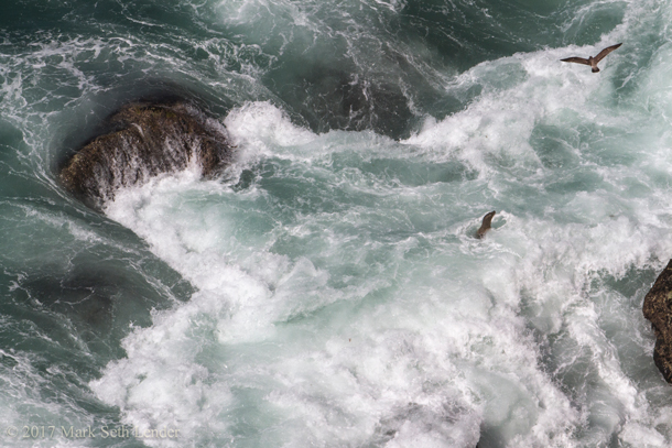
Sea Lions at Play
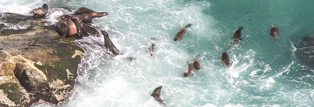
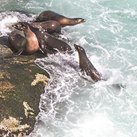
The sea lions of Big Sur. (Photo: Mark Seth Lender)
KAISER: Sea lions are among the most intelligent – and talkative – of marine mammals. And when they are young, like us, they love to play.
DOERING: In Big Sur, our Explorer in Residence, Mark Seth Lender watched with a twinge of envy as young sea lions cavorted in the surf at, an inaccessible cove hundreds of feet below the Pacific Coast Highway.
LENDER: The sea breaks the block of the land, carving the cliff into the shape of two cupped hands, filled with the tide and emptied with the tide. And on the boulders (the size of houses) left behind, young sea lions by the score. They have come to seek the opposite of shelter, a haulout washed by the surf. They are thrown helter-skelter by waves churning above the swell. Clamber up again. Thrown off again. They swirl and swim in the eddies avoiding the respite of the narrow shore until pleasure tires them out. Forty stories below the edge they bark, laying down their playground claim. Forty stories below the edge the sea speaks for itself calling out its distant name:
[SOUNDS OF WAVES AND SEA LIONS]
Sea lion pup in the surf. (Photo: Mark Seth Lender)
Sssshrrrr-Ruffffffff! Shurrrr….
And as the ear is drawn the eye is led there also. The western sun colors young sea lions to golden brown, gleaming, the water streaming from their fur they are like live brown stones. And the green-deep of the sea breaks white, crashing over them.
All this, as it has been, since the ice was beaten back ten thousand years before.
For sea lions for all its turbulence this place was a safe redoubt, unapproachable by sea or land by men carrying pointed stones. And the only thing to fear was of the sea itself and in it: Great White Shark; Orca; an error in timing and the splintering of bones. Tolerable risks. In the everyday life of every… natural… thing.
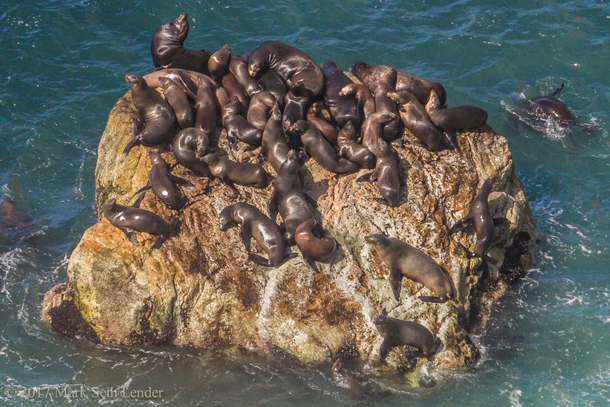
A group of sea lions sunbathe on their favorite rock. (Photo: Mark Seth Lender)
[SOUNDS OF SEA LIONS AND WAVES]
DOERING: And you’ll find Mark Seth Lender’s photos of these sea lions at our website, loe dot org
Related link:
Mark Seth Lender’s website
[MUSIC: Thelonius Monk, “Four In One” on Genius Of Modern Music, Vol.Two, Blue Note]
KAISER: Living on Earth is produced by the World Media Foundation. Our crew includes Naomi Arenberg, Bobby Bascomb, Savannah Christiansen, Noble Ingram, Hannah Loss, Don Lyman, Helen Palmer, Aynsley O’Neill, Adelaide Chen, and Jolanda Omari.
DOERING: Tom Tiger engineered our show, with help from Jeff Wade and Jake Rego. Alison Lirish Dean composed our themes.
KAISER: You can hear us anytime at L-O-E dot org - and like us, please, on our Facebook page - PRI’s Living on Earth. And we tweet from @livingonearth.
DOERING: Steve Curwood is our executive producer. I’m Jenni Doering
KAISER: And I’m Jaime Kaiser. Thanks for listening!
ANNOUNCER1: Funding for Living on Earth comes from you, our listeners, and from the University of Massachusetts, Boston, in association with its School for the Environment, developing the next generation of environmental leaders. And from the Grantham Foundation for the protection of the environment, supporting strategic communications and collaboration in solving the world’s most pressing environmental problems. Support also comes from the Energy Foundation, serving the public interest by helping to build a strong, clean, energy economy, from Carl and Judy Ferenbach of Boston, Massachusetts and from SolarCity, America’s solar power provider. SolarCity is dedicated to revolutionizing the way energy is delivered by giving customers a renewable alternative to fossil fuels. Information at 888-997-1703. That’s 888-997-1703.
ANNOUNCER 2: This is PRI, Public Radio International.
Living on Earth wants to hear from you!
Living on Earth
62 Calef Highway, Suite 212
Lee, NH 03861
Telephone: 617-287-4121
E-mail: comments@loe.org
Newsletter [Click here]
Donate to Living on Earth!
Living on Earth is an independent media program and relies entirely on contributions from listeners and institutions supporting public service. Please donate now to preserve an independent environmental voice.
NewsletterLiving on Earth offers a weekly delivery of the show's rundown to your mailbox. Sign up for our newsletter today!
![]() Sailors For The Sea: Be the change you want to sea.
Sailors For The Sea: Be the change you want to sea.
 The Grantham Foundation for the Protection of the Environment: Committed to protecting and improving the health of the global environment.
 Contribute to Living on Earth and receive, as our gift to you, an archival print of one of Mark Seth Lender's extraordinary wildlife photographs. Follow the link to see Mark's current collection of photographs.
 Buy a signed copy of Mark Seth Lender's book Smeagull the Seagull & support Living on Earth
© Copyright World Media Foundation. All Rights Reserved
Home | Contact | RSS | Donate | Newsletter